Google Maps: Pet-Safe Mode
Concept Design – Mockup
The Path You Walk Together, Worry-Free.
Every walk with your pet should feel light, not cautious. Pet-Safe Mode gently guides you away from noise, heat, or hazards — and toward shade, calm streets, and friendly places. Because every step you take together should be a safe one.
The Project's Origin: The Joy of a Walk, Undermined by Anxiety
This project began with my walks with my dog, Hoho. Our mornings used to be the best part of the day — until construction took over our neighborhood. The streets grew louder, the ground hotter, and our peaceful routine slowly turned into a careful calculation. Every time I opened Google Maps, it showed the “fastest” path — but never the right one. It didn’t know that Hoho hated the sound of drills, or that the asphalt could burn her paws in July. We began walking the same few “safe” routes over and over, avoiding what once felt like adventure. And that’s when it hit me — the map wasn’t built for both of us.
Pet Safety + Navigation

A Walk Is a Shared Adventure
A walk isn’t just exercise. It’s communication, comfort, and trust — a daily ritual that connects two beings who don’t speak the same language. So what if a map could understand that bond?
A true Pet-Safe Mode would be more than a navigation tool. It would become a quiet companion — one that keeps both the human and the pet in mind. It could lead you through shaded paths, point out water fountains, warn of steep stairs, and even show parks with friendly dogs and patient people. A map that notices what matters most: how it feels to walk together.

Insight
Most navigation tools aim to save time. But pet owners care less about minutes and more about moments — the ones that feel calm, safe, and shared.
According to the American Pet Products Association, 66% of U.S. households have a pet, and most owners experience stress about outdoor safety. A map that understands this can turn a routine into a ritual of trust. The key insight: navigation can be emotional design.

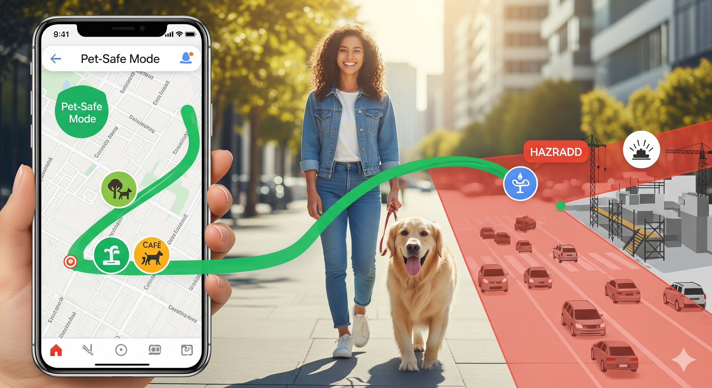
Solution – Pet-Safe Route Mode
🛑 Hazard Awareness
Avoids construction noise, traffic, and summer heat.
Detects environmental hazards like chemical spills or unsafe pavement.
Suggests safer, quieter detours for pets with sensitive hearing or older joints.
🌿 Pet-Friendly Spots
Highlights shaded paths, water fountains, and rest areas.
Marks pet-friendly cafes and parks reviewed by other owners.
Provides instant access to nearby emergency vet clinics.
🐕🦺 Easy Activation & Integration
A single “Enable Pet-Safe Mode 🐾” toggle in Google Maps.
Optionally syncs with pet wearables to track walks and wellness.
Gives small reminders like “Hot pavement today — try a shaded route.”
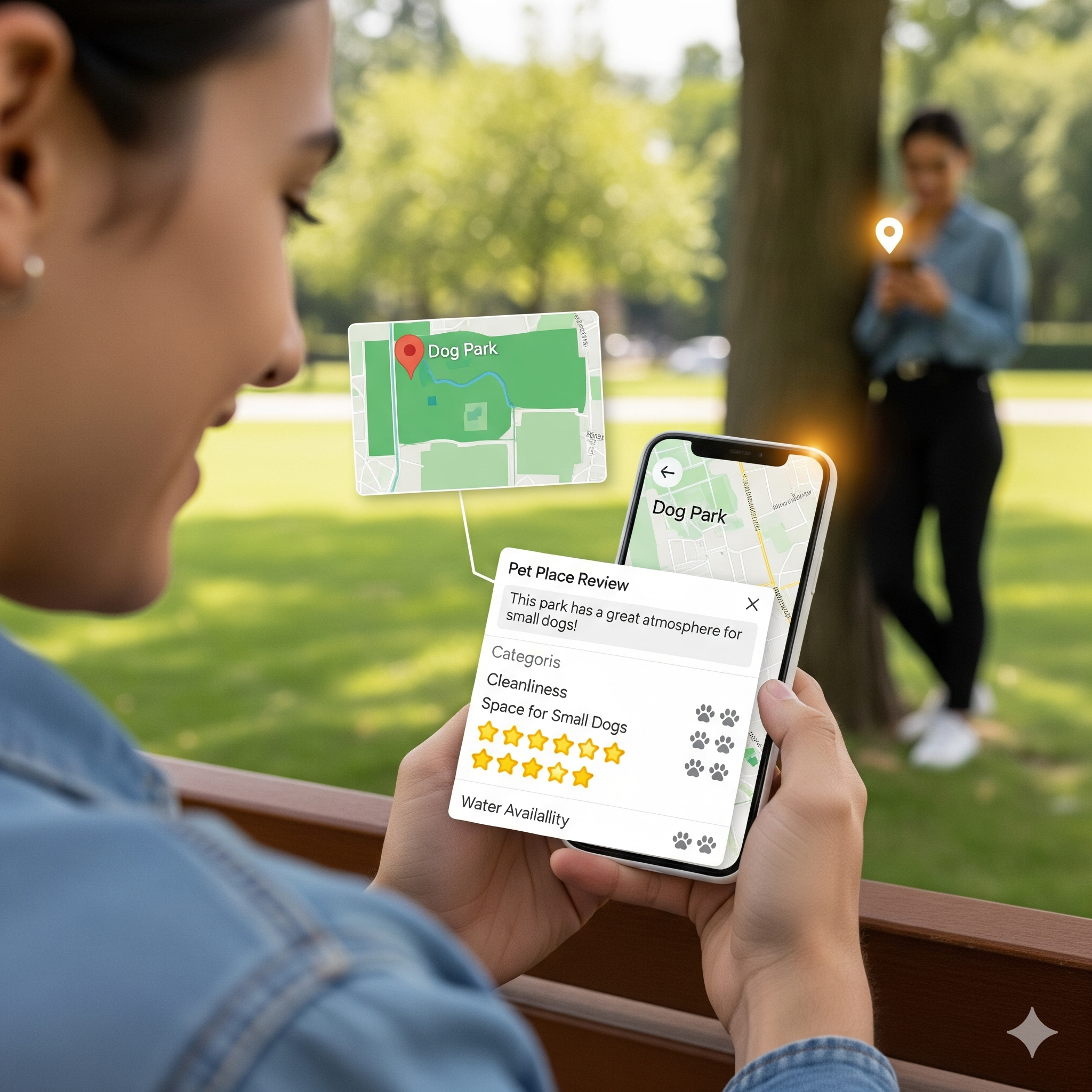
Going Beyond: A Community-Powered “Pet Map”
No one understands local walks better than the people (and dogs) who live them. Through shared reviews and reports, owners can build a living community map — one that evolves with every step. If someone flags a broken sidewalk, loud event, or an off-leash dog, others nearby can instantly avoid it. Together, they make walking safer, softer, and a little kinder for everyone.

Impact
For owners, Pet-Safe Mode replaces worry with peace of mind.
For pets, it means more exploration, more comfort, and more joy.
And for Google Maps, it’s a quiet evolution — from the smartest map to the most empathetic one.
Because sometimes, the best route isn’t the fastest — it’s the one that feels safe to walk together.
—
Speculative UX Concept by Jin Kim
Visual mockups generated with Gemini & ChatGPT (for concept purposes only)